About
TIN CAN BAY
Nestled at the northern edge of the Sunshine Coast and the southern reaches of the Great Sandy Marine Park, Tin Can Bay sits midway between Brisbane and Bundaberg on the Cooloola Coast. Set within the Great Sandy Biosphere Reserve, framed by national parks and overlooking the calm waters of the Great Sandy Strait rich in ancient Indigenous culture, this peaceful coastal village is a hidden eco-tourism gem offering visitors a gateway to one of Australia’s most environmentally diverse and pristine regions including world heritage listed K’gari, formally known as Fraser Island.
The Naming of Tin Can Bay
The area now known as Tin Can Bay was officially renamed from Wallu in 1937. The origin of the name “Tin Can Bay” has been the subject of many theories, both Indigenous and colonial, each offering a different lens into the region’s past.
One popular local story suggests that the name dates back to the early logging days. It is claimed that mail for the timber workers was stored in tin cans for transport on the boats towing logs through the Great Sandy Strait, leading to the informal use of the name “Tin Can Bay.”
Several other theories have been published over the years:
- In his book Winds of Change, Ian Pedley writes:
“How Tin Can Bay got its name is a subject of controversy. The generally accepted theory is that it came from ‘tun-kin’, the Aboriginal word for dugong. Others claim it came from ‘tin-kin’ meaning big fish, or from ‘tindhin’, the Aboriginal word for mangroves.” - According to Wikipedia, the origin of “Tin Can” is believed to stem from an Indigenous name possibly:
- Tinchin, meaning mangrove in the Yugarabul dialect of the Yuggera language, or
- Tinken, meaning a vine with large ribbed leaves, from the Doombarah Clan, Dulinbara dialect, of the Kabi language.
- Another theory involves Zachariah Skyring, a European settler who was reportedly made a blood brother of the local Indigenous community and learned their language. He said the local Aboriginal word for the area was Tuncunba, where “ba” means “place of” and “tuncun” means “plenty”—thus, “place of plenty.”
Local cultural leaders offer the most culturally grounded explanation:
The name Tin Can Bay is believed to derive from Dun’gun’Bah, meaning “plentiful place,” a reference to the belly of the dugong, a culturally significant marine animal. This name comes from Yuan’gun, a word in the Dungadji dialect of the Gubbi Gubbi language group (nation).
This dialect is spoken by the Bidhala Dambari (coastal people who eat the shellfish) of the Dullinbara Tribe, and shared with the Ngalingbara of the Budala and Badjala peoples, coastal communities to the north, including River Heads, Hervey Bay and northern K’gari (Fraser Island).
Getting To Tin Can Bay
Tin Can Bay is easily accessible by road and makes for a scenic drive from several major hubs:
- Just 2.5 hours north of Brisbane
- Around 1.5 hours from Sunshine Coast Airport
- Approximately 2.5 hours south of Bundaberg
Whether you’re traveling for a weekend escape or passing through on a coastal adventure, Tin Can Bay is the perfect detour into nature.
Tin Can Bay Highlights
Tin Can Bay is a coastal gem waiting to be explored by nature lovers, families, and outdoor adventurers alike.
Cool off in the bay waters or local pool, tee off on the scenic 18-hole golf course, enjoy a game of bowls, or make use of the public tennis courts. Wander or wheel your way along kilometres of flat, accessible pathways that showcase stunning coastal views, perfect for photography and peaceful exploration.
Take to the calm waters for kayaking, boating, or kitesurfing, with easy access via local boat ramps. Cast a line for estuary or reef fishing, or experience the wonder of hand feeding wild dolphins at the Barnacles Dolphin Centre.
Discover the region’s incredible biodiversity along bird trails winding through Ramsar-listed wetlands, vibrant wildflower reserves, and the scenic boardwalk overlooking the Great Sandy Marine Park. Cross the striking Nola Bale Bridge over the mangrove lined tidal inlet and look out for the soldier crabs dancing across the sandflats at low tide.
Just a short drive away lies the Great Sandy National Park and Cooloola Recreation Area, offering fresh-water swimming at Searys Creek, the lush Bymien rainforest, tranquil Poona Lake, windswept Carlo Sand Blow, the iconic Double Island Point and Inskip Point. From there, you can access K’gari (Fraser Island), a World Heritage-listed wonder known for its crystal-clear lakes, towering rainforests, and famous 75 Mile Beach.
Whether you’re here for adventure or relaxation, Tin Can Bay is your perfect base to explore the natural treasures of Queensland’s Cooloola Coast.
Naturally Protected
Tin Can Bay sits at the heart of one of Australia’s most protected and environmentally important regions while forming part of a globally significant network of safeguarded environments. The surrounding region is encompassed by the UNESCO Great Sandy Biosphere, while national parks, the Great Sandy Marine Park and Ramsar-listed wetlands safeguard an extraordinary mix of coastal, marine, forest and wetland ecosystems. This network of preservation ensures Tin Can Bay remains a place where nature thrives and where visitors can experience an unspoilt coastal environment shaped by conservation, culture and care.
Great Sandy Biosphere
The Great Sandy Biosphere Reserve was designated a UNESCO Biosphere Reserve in 2009, following decades of scientific research, environmental advocacy and strong community involvement. The listing recognises the region as a global model for sustainable land and sea management, where conservation, local livelihoods and tourism coexist. It encompasses internationally significant features including K’gari – Fraser Island (the world’s largest sand island), the Great Sandy Strait, Ramsar-listed wetlands and critical habitats for marine turtles, dugongs and migratory birds, placing it alongside global icons such as the Galápagos Islands and the Everglades.
Rather than being locked away, the biosphere promotes the responsible use of natural resources while safeguarding ecosystems for future generations. Covering 874,000 hectares of land between Gympie and Bundaberg and 540,000 hectares of marine park, it reflects a shared commitment by governments, Traditional Owners, conservation groups and local communities to protect one of Australia’s most remarkable natural landscapes.
The biosphere extends from a volcanic hinterland with Mothar Mountain near Gympie reaching 450 metres above sea level to the coast and sea. Six major river systems flow through the reserve: the Noosa, Mary, Susan, Burrum, Isis and Cherwell Rivers. The region is home to the world’s tallest and most diverse rainforest growing on sand, alongside evolving dune systems that support diverse plant communities. Despite nutrient-poor sandy soils, a wide range of ecosystems thrive, including mangrove forests, eucalypt forests, riparian rainforest and dry rainforest dominated by satinay and turpentine species.
In total, 96 regional ecosystems are found within the biosphere. The area supports habitats for 49% of Australia’s bird species and remarkably, 40% of the world’s perched lakes are located within the Great Sandy region such as Poona Lake.
Ramsar Wetland of International Significance
In 1999, the Great Sandy Strait, encompassing Tin Can Bay and the Tin Can Inlet, gained international recognition as a Ramsar Wetland of International Importance. Listed as Site 992, the area was acknowledged for its exceptional ecological diversity and its role as the largest system of tidal swamps in Southeast Queensland. Its intertidal flats, expansive seagrass beds, mangroves, salt flats and saltmarshes support an extraordinary array of life, from migratory shorebirds and seabirds to marine fish, crustaceans, oysters, dugongs, sea turtles and dolphins.
The Ramsar Convention on Wetlands is the oldest of the modern global environmental agreements to develop and maintain an international network of wetlands, established to halt the global loss and degradation. Adopted in Ramsar, Iran, in 1971, the treaty promotes the conservation and sustainable use of wetlands for the benefit of both nature and people. Ramsar sites protect internationally important ecosystems while supporting local communities through recreation, cultural values, and vital services such as flood control, water filtration and coastal protection.
The best time for migratory wader birdwatching in Tin Can Bay is from September to April, when thousands of shorebirds arrive from Siberia and Alaska to feed and rest in the Great Sandy Strait. Numbers build through spring and summer, peaking around late January to February. For the best viewing, plan your visit around the tides. Low tide reveals sandbanks where birds feed, while rising tides, about an hour before and after high tide, encourage large flocks to roost together. Popular viewing locations include Norman Point and Mullens Creek Park, where birds can often be seen resting in close groups.
Great Sandy National Park
Great Sandy National Park protects one of Australia’s most remarkable and ancient sand landscapes, shaped by wind, water and time. The park is divided into two distinct but interconnected sections: Cooloola and K’gari, together safeguarding an environment found nowhere else on Earth.
The Cooloola Recreation Area stretches along the coast between Noosa Heads and Rainbow Beach, covering approximately 184,000 hectares of sweeping dunes, coloured sand cliffs, coastal forests, freshwater lakes, wetlands and river systems. To the north lies K’gari (formerly known as Fraser Island), the world’s largest sand island, with almost all of its 165,000 hectares protected as national park.
For much of the 20th century, this region was heavily logged and targeted for sand mining, placing its fragile ecosystems under threat. By the late 1960s and 1970s, growing public concern sparked one of Australia’s most significant environmental movements. A major turning point came when the Commonwealth Government refused export licences for mineral sands from Fraser Island, signalling a shift toward conservation.
In 1971, advocacy by the Fraser Island Defenders Organisation led to the declaration of a 25,000-hectare national park on K’gari. Momentum continued in Cooloola, where widespread community campaigns, including petitions and thousands of postcards sent to government, resulted in sand mining being banned. In 1975, the first stage of Cooloola National Park was gazetted, permanently protecting its ancient sandmass, forests and waterways.
Once a contested industrial landscape, the Great Sandy National Park has become a symbol of environmental change and collective action. Today, it stands as a protected wilderness of international significance and a powerful example of how conservation, community advocacy and respect for natural systems can shape a sustainable future.
Great Sandy Marine Park
The Great Sandy Marine Park protects an extensive and diverse stretch of Queensland’s coastline, extending from Baffle Creek in the north to Double Island Point in the south. Encompassing Hervey Bay, the Great Sandy Strait, Tin Can Inlet and the waters off the eastern coast of K’gari, the park covers more than 6,200 square kilometres of tidal lands and marine environments.
Established in 2006, the park brought together the former Woongarra and Hervey Bay Marine Parks, creating a unified marine reserve managed by Queensland Parks and Wildlife Service. Its waters protect an extraordinary range of habitats including coral reefs, seagrass meadows, mangroves, estuaries, saltmarshes and sandy beaches.
These interconnected ecosystems support an abundance of marine life, from dugongs, dolphins and marine turtles to migratory shorebirds, manta rays and humpback whales. Seagrass meadows provide vital feeding grounds, while mangroves and estuaries serve as important nurseries for fish and crustaceans. The park also contains eleven Fish Habitat Areas, safeguarding critical breeding grounds for Queensland’s fisheries.
One of the park’s most significant conservation roles is the protection of the critically endangered grey nurse shark. Wolf Rock, near Rainbow Beach, is one of only four known aggregation sites in south-east Queensland and is the only confirmed gestation site for the species along Australia’s east coast, making the Great Sandy Marine Park internationally important for marine conservation
Culturally Connected
Tin Can Bay sits within a landscape shaped not by boundaries, but by connection. Rather than a single cultural site, the area formed part of a network of places that supported Indigenous life, ceremony and movement across the coast. The Dullingbara people of the Gubbi Gubbi language nation have long been connected to this Country, from Cooloola to K’gari, carrying Dreamtime stories and knowledge through generations.
The name Tin Can Bay is believed to come from Dun’gun’Bah — “plentiful place” — a reference to the dugong, whose belly symbolised abundance and nourishment. This meaning is linked to Yuan’gun, from the Dungadji dialect spoken by the Bidhala Dambari, coastal people who lived closely with the sea and its resources.
The broader Tin Can Bay area was a place of gathering, with locations such as Mullens Creek, Poverty Point and Searys Ledge drawing people from across the region to share food, ceremony and celebration following great harvests from land and sea. Nearby, Yuanghan Wungun (Wide Bay Training Area) and Nunmaloo (Kauri Creek) have long been places of learning and transformation, where boys were guided into manhood. To the southwest of Freshwater Road, including Poona Lake, the land holds spiritual significance for women and children.
Dungunbah (Tin Can Bay) continues to hold a special place in the spirit of the Dullingbara people, remembered always as a place of abundance, connection and shared life.
Ancient Waters, Living Culture
For millennia, Tin Can Bay has been shaped by water, movement and deep cultural connection. Long before the coastline took its present form, the land and sea were joined, and great lakes and rivers flowed through what is now the Great Sandy region. As water shifted and landscapes transformed, Aboriginal people adapted, guided by an intimate understanding of Country and the lifeforce carried by water.
Fishing here was never simply an activity, it was a relationship with land and sea, shaped by seasons, tides and respect for the habitats that sustained life. Knowledge was passed carefully through generations, ensuring that resources were used wisely and protected for those yet to come. Each catch was part of a broader responsibility to care for Country.
Long outrigger canoes known as gombar, crafted from buoyant nunmaloo (Kauri pine), carried people across these ancient waterways. From the Moorooboogoola (Mary River) and through the Great Sandy Strait, these journeys connected communities, food sources and stories, reflecting a living culture deeply attuned to change, balance and continuity.
Yuloo of the Bay
The relationship between humans and dolphins (yuloo) in the Tin Can Bay area stretches back thousands of years. Aboriginal people developed a unique cooperative fishing practice, working with yuloo to herd fish into shallower waters where they could be more easily caught. The catch was then shared, reinforcing a deep respect for the yuloo and the waters they inhabited.
Fishing followed seasonal rhythms. During specific times of the year, spawning fish were sought, with roe carefully collected and used as nourishment for infants. These fishing activities often involved miri, companion dogs that assisted people and yuloo in guiding fish and retrieving the catch. This cooperation highlights a sophisticated understanding of ecology, behaviour and balance within the natural world.
Yuloodara - The Great Golden Dolphin
In the Dreaming, all things are connected with the land, sea and sky moving as one. In those ancient times, when water covered the country, celestial spirits such as Biral, the Great Creator, Djagun, Mother Earth, and Biralugan, the Female Creator, watched over the world as it took shape.
They tell of Yuloodara, the Great Golden Dolphin, who travelled the vast waters. As he swam and breathed, his movements shaped the land beneath the sea, forming the contours of country as the waters withdrew. Yuloodara’s story lives on in the rhythms of the bay, reminding us that the land itself carries memory, spirit and connection.
Dungunbah Coastal Dialect
PLACES
Boomadjin – Lake and mountains in the Lake McKensie area on K’gari
Ngutharu – Noosa
Wungaan – Area of the bluff on K’gari to Inskip
Djakahn – Rainbow Beach cliffs
Mudlo– Rainbow Beach coffee rock areas
BulaBula Milbi – Double Island Point
Deewanan – Teewah (Tea tree forest)
Gootharaba – Cootharaba (lakes and woodlands area)
Moorooboogoola – Mary River
Yuanghan Wungun – Vicinity covering the Wide Bay Training Area
Nunmaloo – Kauri Creek
LIFE
N’gara – Hello
Bundjalum – Hello everyone
Yuan’gun – Dugong
Yuloo – Humpback dolphin
Wongari – Wild dingo
Miri – Camp/companion dingo
Guriman – Flying fox (bring rainforest and replenishment)
Narahwi – Ocean
Daringa – Saltwater
Nunmaloo – Kauri pine
Nature Encounters
Tin Can Bay invites you to experience nature up close. Seasonal wildflowers, abundant birdlife and a variety of marine creatures thrive, offering countless opportunities to observe and appreciate the unique ecosystems that shape the region.
Dolphins Daily
The shallow coastal waters of Tin Can Bay provide important habitat for the Australian humpback dolphin, a species formally recognised in 2014 as distinct from the Indo-Pacific humpback dolphin. These dolphins have a subtle hump at the base of the dorsal fin and display remarkable variation in colour, from white and pink through to grey. As individuals mature, their forehead, beak and dorsal fin become paler, resulting in a speckled or freckled appearance. Over time, the dorsal fin softens and rounds, with some older dolphins developing a noticeably floppy tip.
Living in turbid inshore waters, Australian humpback dolphins rely heavily on sound. In addition to high-frequency echolocation clicks used for navigation and hunting, they are highly vocal, producing whistles and screams in a range of patterns to maintain social contact. Their flexible feeding habits allow them to exploit many habitats, including mangroves, sandy-bottom estuaries, seagrass meadows and nearshore coral reefs. Feeding can involve individuals spread across wide areas or tight groups targeting localised prey, and occasionally includes dramatic chases into shallow water where dolphins briefly beach themselves to catch fish.
Tin Can Bay offers one of Australia’s most unforgettable wildlife experiences. It is one of only three places in the country where you can hand-feed wild dolphins. For a truly memorable moment, head to the Barnacles Dolphin Feeding Centre at Snapper Creek Boat Harbour and come face to face with these gentle marine icons during the morning feeding program.
Wildflower Wonders
The Cooloola Coast is a botanical wonderland, home to a rich variety of plant habitats including rainforests, eucalypt woodlands and the unique Wallum heathlands. These sensitive and protected environments burst into colour at different times of the year, with seasonal wildflower blooms creating a vibrant mosaic across the landscape and attracting butterflies and birdlife.
Visitors can enjoy views of these intricate natural beauties along the sealed Tin Can Bay Wildflower Walk and foreshore pathways, which offer peaceful opportunities to observe and photograph native plants in their natural setting or trek into the National Parks for a closer nature experience.
To help protect this delicate ecosystem, please admire wildflowers without picking them, leaving them ensures the natural cycle continues and others can enjoy the display. For more information, including photographs and plant descriptions, pick up a copy of the Cooloola Wildflowers and Trails booklet by Cooloola Coastcare.
Birdlife of the Bay
With over 140 recorded bird species, Tin Can Bay is one of the Cooloola Coast’s most rewarding birdwatching destinations. Migratory shorebirds arrive seasonally, joining resident species drawn to the area’s rich mix of habitats, from wallum heath and woodlands to wetlands, mangroves and tidal flats. This natural diversity supports an impressive array of birdlife, including rare and threatened species.
The Tin Can Bay Foreshore Bird Walk invites visitors to slow down and observe. Interpretive signs enhance the experience as the trail meanders through open green spaces, along sandflats and into tranquil bushland, with each habitat offering new sightings and surprises. During certain times of the year, flocks of Rainbow Lorikeet return to roost in the foreshore trees, creating a vibrant spectacle of colour, sound and playful interaction.
For inspiration and identification tips, explore the Birding Cooloola website or the Cooloola Coastcare Cooloola Birds of Interest booklet including suggested trails. Experienced birders are encouraged to grab their gear and explore beyond the foreshore.
Tips for Birdwatchers
- Check local tide times, as bird activity closely follows feeding and roosting cycles.
- Keep a safe, respectful distance, particularly from threatened species such as the critically endangered Eastern Curlew, and observe quietly.
- Wear sun protection including hats and sunscreen and apply insect repellent when needed.
- Choose sturdy footwear for foreshore walks and tidal flats; avoid walking barefoot on mudflats.
Carry plenty of water, especially on longer walks, and bring a communication device. - Be mindful of marine stingers, avoid touching marine life and use marked paths and bird trails to reduce disturbance to sensitive habitats.
Marine Turtles
There is nothing quite as magical as watching a turtle glide through the water and Tin Can Bay offers wonderful opportunities to spot them feeding and resting among the mangroves. Whether you’re canoeing, swimming, sailing or joining a guided tour or charter, you may be lucky enough to encounter one of these gentle ocean travellers.
From November to April, the beaches of the Cooloola Coast transform into a vital nesting ground for endangered marine turtles. During this special time, females come ashore under the cover of darkness to lay their eggs, and months later, tiny hatchlings emerge to make their first journey to the sea. The most commonly seen species include Green, Loggerhead, Hawksbill and Flatback turtles. This region plays an important role in turtle conservation, with local sand temperatures helping to produce male hatchlings, essential for maintaining healthy turtle populations.
By travelling thoughtfully and respecting turtle habitat, visitors help ensure Cooloola’s beaches remain a safe nursery for these remarkable animals, allowing future generations to experience this truly magical natural event.
Soldier Crabs
These tiny ‘armies of the mudflats’ can be spotted around Tin Can Bay during low tide, especially in the Norman Point area. Watching their fascinating movements and group behaviour can provide hours of entertainment. As captivating as they are, soldier crabs are living creatures and should be respected, admired from a distance and left undisturbed in their natural habitat
Fun Facts About Soldier Crabs
- Masters of the tide
Soldier crabs run on an internal clock that’s perfectly synced with the tides. When the tide comes in, they bury themselves in the sand. As soon as it goes out, they emerge to feed on the exposed sandy mudflats. - They walk straight ahead
Unlike most crabs that shuffle sideways, soldier crabs are one of the few species that can walk straight forward. - Strength in numbers
These crabs earn their name by ‘marching’ together in huge groups across the mudflats. Moving en masse helps protect them from predators. - Disappearing act
When threatened, soldier crabs quickly screw themselves into the sand using a corkscrew motion, vanishing completely in seconds. - Nature’s Easter eggs
With their bright colours, soldier crabs are often nicknamed ‘Easter eggs on legs.’ They’re also one of the only animals in the world known to have striking purple knees! - Breathing from the back end
Soldier crabs have adapted to life on land by drawing water into their gills through tiny hair-like fringes at the back of their shell. To stay hydrated and keep breathing, they often squat in shallow puddles to ‘recharge.’ - Boys and girls apart
Soldier crabs tend to hang out in same-sex groups. Large clusters of males and females are often seen roaming separately and scientists still aren’t sure why. - Masters of disguise
Their bright blue colouring sends a warning signal that usually means ‘poisonous’ in the animal world. But soldier crabs are harmless! This clever trick is called mimicry. - Fair-weather fans
Soldier crabs prefer warm conditions. When temperatures drop, fewer of them are seen wandering across the flats. - The cleaners of the mudflats
Soldier crabs play an important role in keeping mudflats healthy. They scoop up sand, filter out bacteria and organic matter for food, then spit out clean sand behind them.
Cooloola Monster
The Cooloola Monster (Cooloola propator) is one of the Great Sandy region’s most unusual natural discoveries. First found in 1976, this strange, burrowing insect wasn’t formally named until 1980, following years of mystery and investigation.
The discovery began when a single male specimen was accidentally captured in a pit trap during a Queensland Museum survey near Poona Lake. Scientists soon realised they had found something extraordinary, an entirely new insect family and the first discovered anywhere in more than 80 years. However, with only one specimen and little understanding of its underground lifestyle, finding others proved challenging.
Public curiosity grew after a second specimen was unearthed on K’gari during construction works, sparking media coverage and public ‘wanted’ posters by the research team. More sightings slowly followed, until the final breakthrough came when a National Parks ranger uncovered a female specimen while digging at a campground in Cooloola. This crucial find allowed scientists to formally describe the species and establish the new family Cooloolidae.
Today, the Cooloola Monster remains a symbol of the region’s hidden biodiversity. Its name, propator, means ‘the first of its kind,’ a fitting title for one of the rarest insect families on Earth. Discoveries like this highlight just how much remains hidden beneath the sands of the Cooloola region.
Tin Can Bay Over Time
The story of Tin Can Bay’s early settlement is one of hard work and resourcefulness. Pioneers made their lives along the bay through fishing, dairying, timber and small-scale trade, shaping the town and its waterways into a vibrant coastal community.
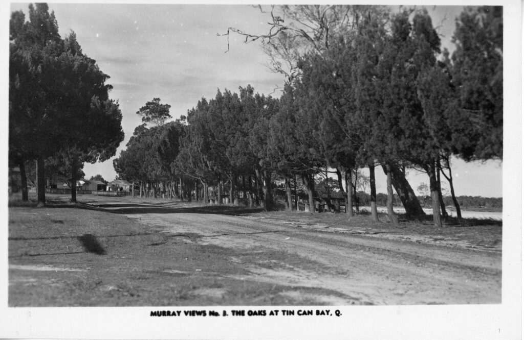
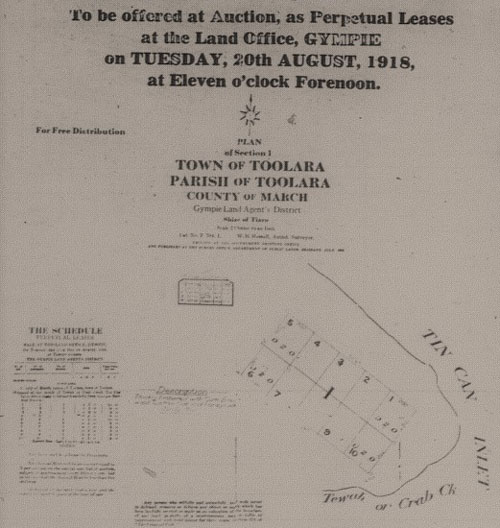
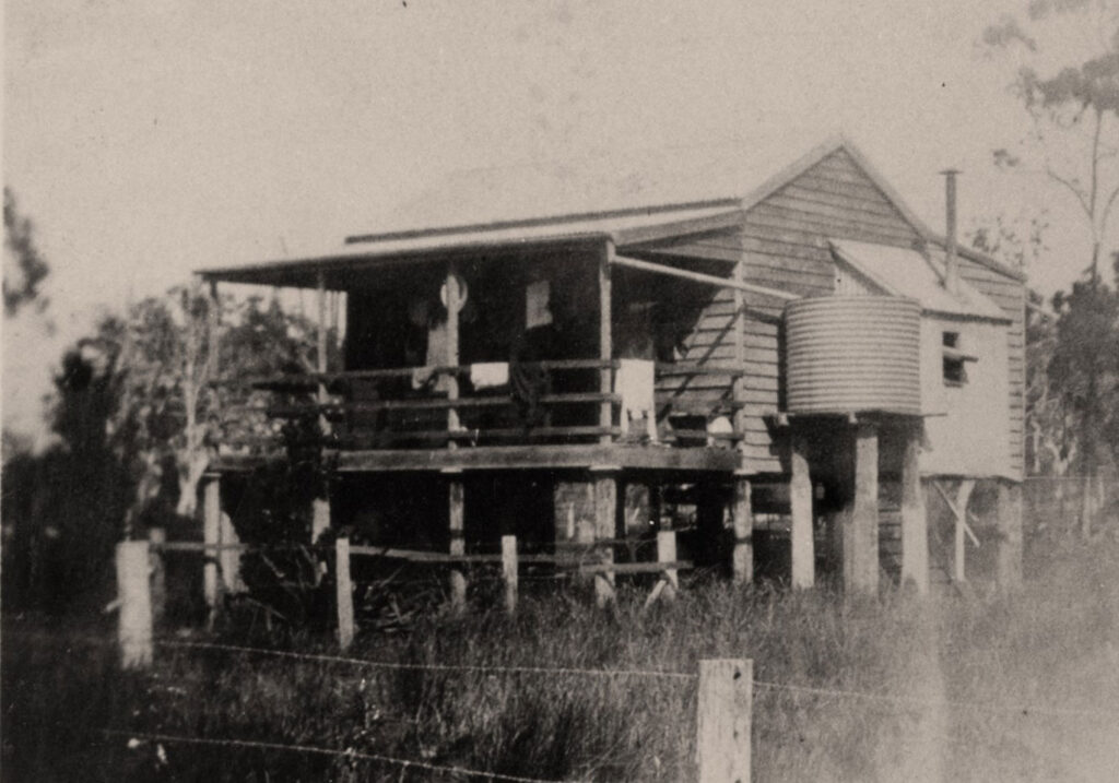
The Makings of a Township
How Tin Can Bay Officially Found Its Place on the Map
The first formal effort to establish land ownership in the Tin Can Bay region began in 1918, when ten allotments were offered at public auction in the proposed Town of Toolara, known locally today as Crab Creek. However, historical records show that not a single allotment was sold at that time.
The initiative was revived in 1922, when the Queensland Lands Department reoffered the unsold Toolara lots alongside 36 town and suburban allotments in the newly surveyed Town of Wallu, the name Tin Can Bay was known by at the time. The auction was held on 10th November 1922.
Of the 25 town lots available in Wallu, 17 were sold under perpetual lease agreements. Early leaseholders pioneers M.E. Pearce, W. Bushell, T. H. Steele, B. Dickson, D.D. Woodrow, A.G.D. Austin, A.J. McFie, F.J. Gillis, R.M. Hose, Mabel C. Power, S.F. Sheldon, D. Mulcahy, A.Williams, A. Chisholm, B. Power, L.M. Pearce, A.D.S. Skyring and J.W. Burkhardt. Prices ranged from 8 to 36 pounds, reflecting the modest beginnings of what would later become a thriving coastal community. Despite renewed interest, the lots in Toolara remained unsold.
This successful land sale on 10 November 1922 is now recognised as the official establishment of the township, marking the formal beginning of the area we know and love today as Tin Can Bay.
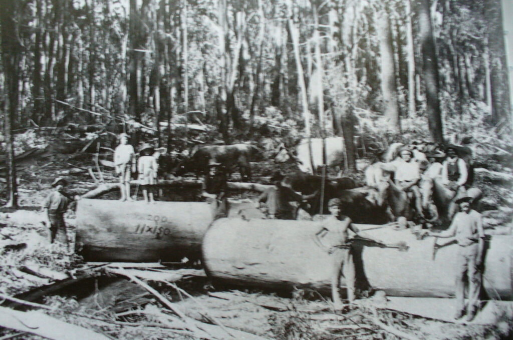
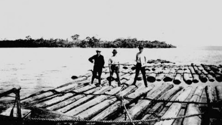
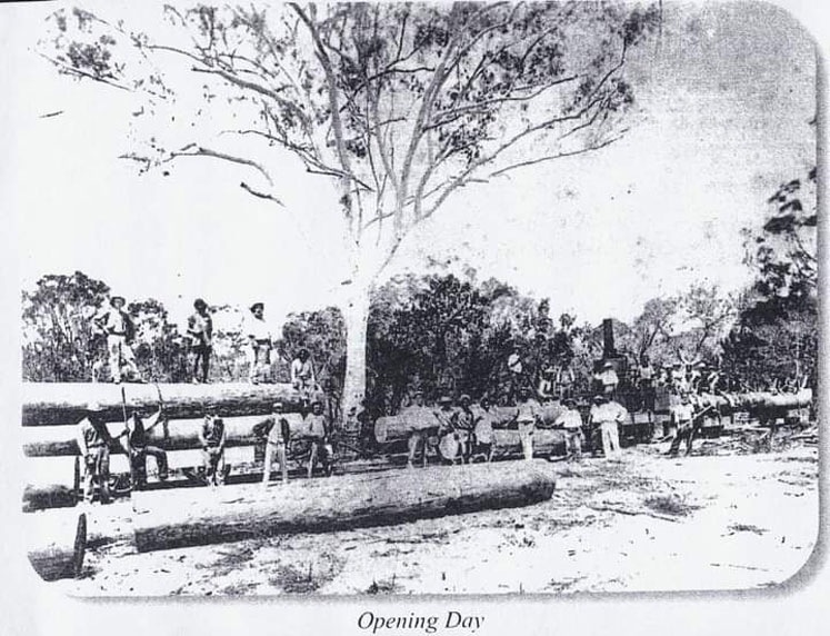
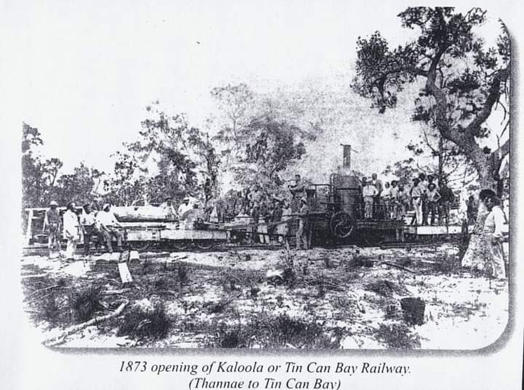
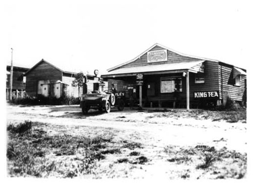
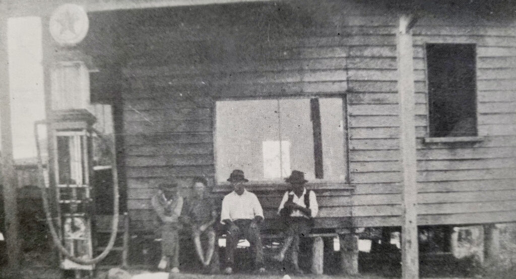
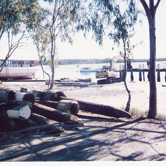
Early Industry in Tin Can Bay
Dugong
Tin Can Bay’s earliest recorded industry was the processing of dugong oil at Kauri Creek in the mid-1800s. Dugong flesh was boiled to extract oil prized for medicinal uses, the meat was a valuable food source and the skins were used for many uses, even as brake shoes on buggies and wagons. The fishery peaked in the 1870s but declined quickly as dugong numbers fell. Though short-lived, it remains one of the first industries to shape the region’s early history.
Oysters
Oysters were another early industry that helped put Tin Can Bay on the map. In the 1870s, R.W. Leftwich & Sons acquired all the oyster leases in the Tin Can Bay Inlet and established a camp near Eudlo Point, on the opposite side of Snapper Creek from where the township of Tin Can Bay stands today. They operated the leases until 1924, when they sold the business to the Moreton Bay Oyster Company.
Timber
One significant early industry was timber, with William Pettigrew and William Sim dominating the trade throughout the Cooloola region.
Pettigrew’s men used bullock teams to haul Kauri pine logs from Woolann (now the area around Lake Poona) to the mouth of Seary’s Creek. There, the logs were tied into large rafts and towed through the Tin Can Bay Inlet.
To increase production, the first steam locomotive built in Queensland, constructed in Maryborough at the Walker Brothers Foundry, was brought in to operate in what is now the Cooloola Recreation Area of the Great Sandy National Park. This marked the creation of Queensland’s first major private railway, operating from 1873 to 1884.
Logs were transported via the Cooloola Tramway, opened on 29 October 1873, to the coastal terminus at Poverty Point, from where they were shipped up the Great Sandy Strait to Pettigrew’s Maryborough mill. Tragically, just three weeks after the tramway opened, William Sim was killed by a five-foot-diameter log while unloading.
Today, visitors can still see remnants of the old jetty at Poverty Point or drive the Eastern Firebreak in the Camp Milo area, the site of the original inland tramway terminus before its extension into the Broutha Scrub.
Bananas
During the Great Depression in the early 1930s, an experimental banana plantation was established at Seary’s Scrub in a search for new economic opportunities? Unfortunately, the bananas failed to thrive, and the plantation was abandoned by 1936.
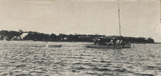
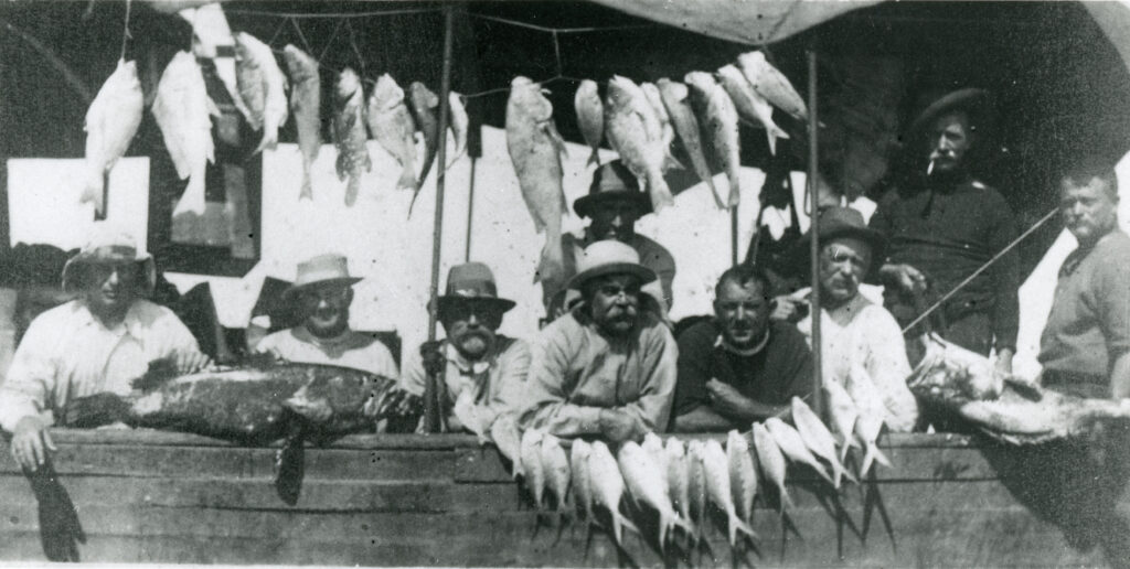
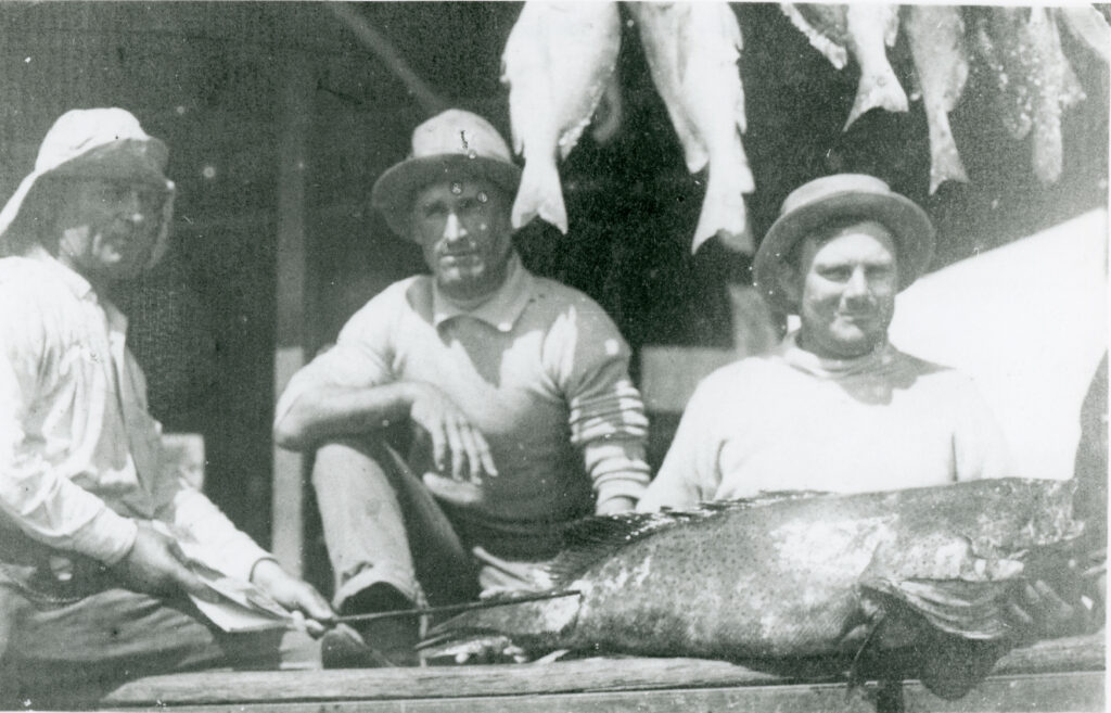
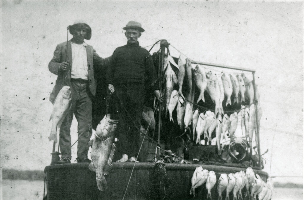
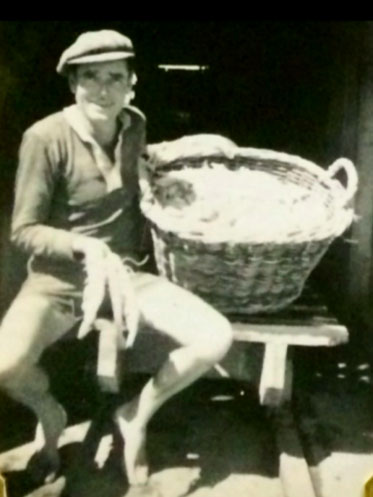
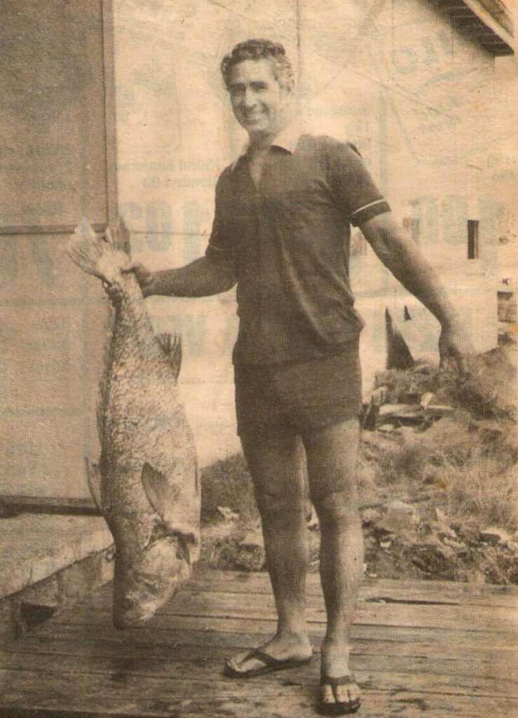
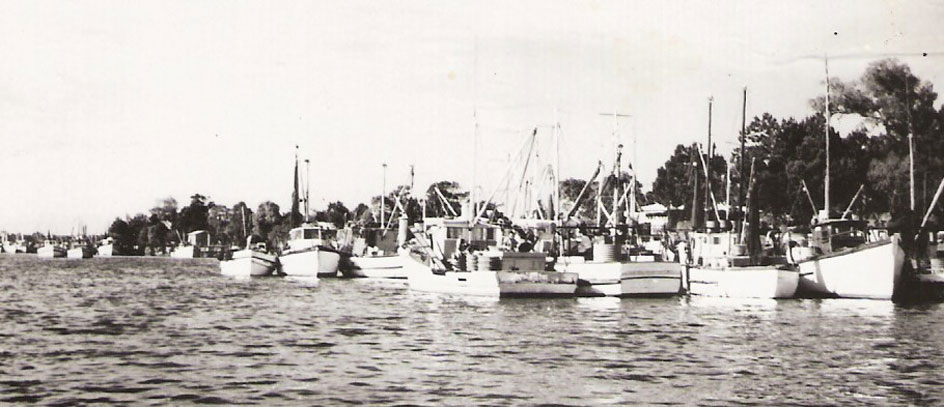
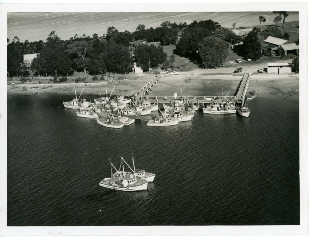
Fishing in Tin Can Bay – A Way of Life
Fishing has been both a livelihood and leisure pursuit in Tin Can Bay for well over a century. The area’s sheltered waters, abundant marine life and strategic location made it an ideal base for early commercial and recreational fishing.
Before the introduction of modern refrigeration, fish were traditionally smoked to preserve them for storage and transport to regional markets. This method not only extended the shelf life but also added distinctive flavours that became a part of the local food culture.
A significant shift came in the 1930s with the establishment of an ice works facility near what is now Jew Street. The availability of ice revolutionised the fishing industry, allowing fish to be transported fresh to markets in Maryborough, Gympie and beyond. This development helped expand commercial operations and contributed to the economic growth of the town.
Early beach fishing in remote areas such as K’gari (Fraser Island) demanded a great deal of ingenuity. Fishermen sometimes ferried vehicles across the water by lashing dinghies together, laying planks across them and balancing the car on top, all while frantically bailing to keep the makeshift raft afloat. Other vehicles were shipped over and hoisted onto the island using a trawler’s boom, enabling fishermen to travel the coastline and bring their catch back to the bay.
The Lee Family – A Legacy in Tin Can Bay
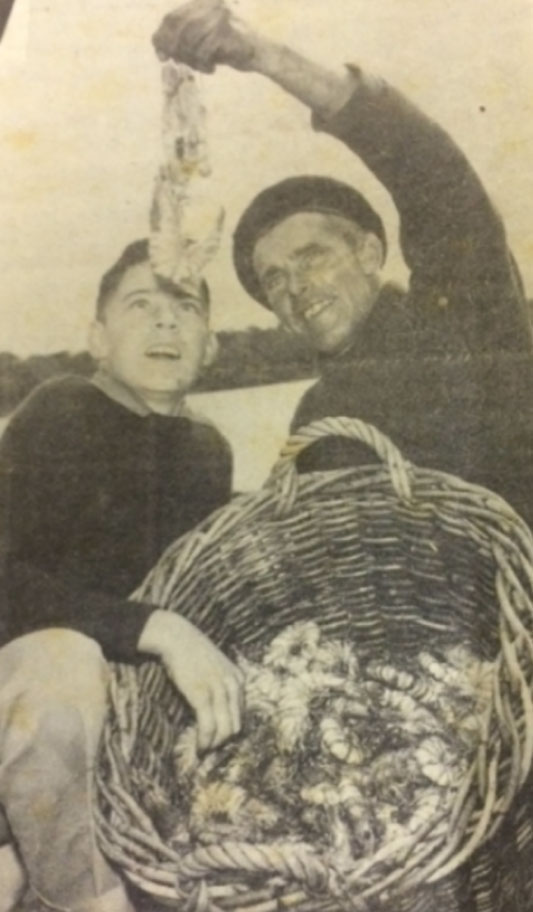
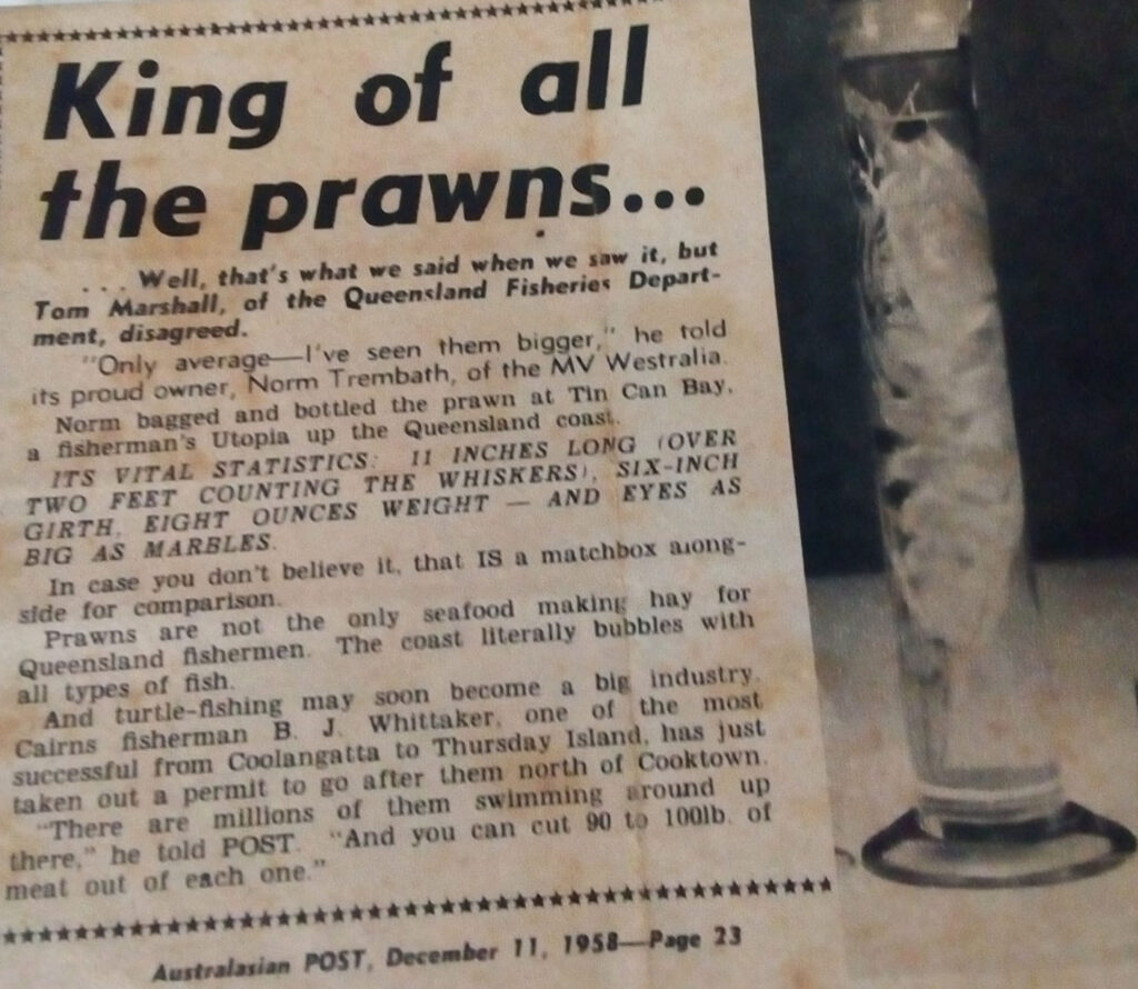
When Les Lee first arrived in Tin Can Bay in 1929, he likely had no idea that his family name would become deeply woven into the town’s history for generations. Les came to the bay after the collapse of the banana industry forced him to close his boarding house on Wolvi Mountain.
Starting out, he worked as a crabber in Mullen’s Creek, transporting his catch to Gympie by horse and cart each week. He later moved into net fishing, becoming a well-known figure among the early fishing pioneers of the region. Les also played a role in the experimental banana plantation at Seary’s Scrub during the 1930s, a short-lived venture that was ultimately abandoned.
In 1944, the Queensland Fish Board established a market in Tin Can Bay and Les served as manager on two separate occasions. He also contributed to the construction of the new Fish Board building in the early 1970s, helping to modernise the local fishing infrastructure.
The Lee Fishing Company was officially established in 1951 by Les’s son, Vern Lee, who worked the local estuaries and creeks as a fisherman and crabber. Today, the family legacy continues with Peter Lee, Vern’s son, and his wife Lisa, who manage the Fish Board and uphold the Lee family’s enduring connection to Tin Can Bay’s maritime industry.
From humble beginnings to a cornerstone of the local fishing community, the Lee family story is a testament to resilience, hard work and a deep-rooted bond with the sea.
The Prawn Boom
In the late 1950s, Tin Can Bay transformed almost overnight from a quiet village into a bustling boomtown. The catalyst? Prawns.
Local fisherman Fred Langford discovered rich prawn grounds off the western side of Inskip Point, with the main fishing area located just outside the bar. Word spread quickly and within weeks, over 70 boats had arrived in the bay to capitalise on the discovery. Among the first to arrive were the Tamoi, Viking and Pathfinder.
This marked the beginning of a thriving commercial prawning industry, firmly placing Tin Can Bay on the map.
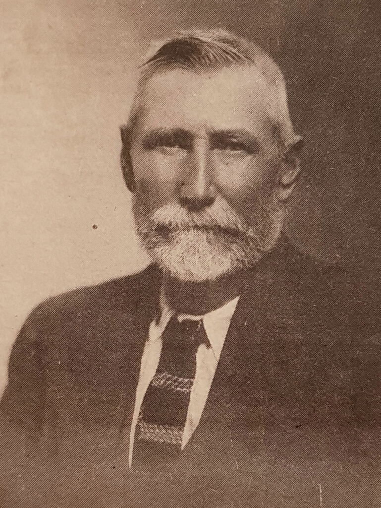
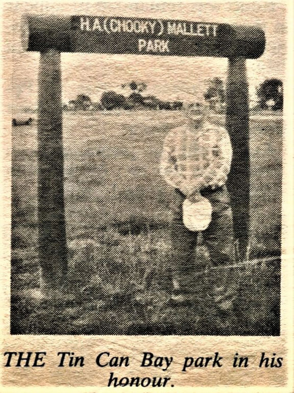
Cr Tom Steele – A Community Pioneer
When the southern sector of Tiaro Shire was incorporated into Widgee Shire, Mr Tom Steele became the first elected Councillor for Tin Can Bay. Known for his hands-on approach and strong community spirit, Cr Steele often led by example working side-by-side with road crews, grubber and shovel in hand, to help construct the early road to the coast.
Tom Steele served on the Widgee Shire Council from 1911 to 1921 and again from 1933 to 1936, passionately advocating for the growing township. After retiring, he settled in Tin Can Bay as one of its earliest permanent residents, running a local boarding house with his daughter Millie.
Tom passed away in 1941 from blood poisoning, but his legacy lives on. His significant contributions to the region are honoured through the naming of Cr Tom Steele Recreation Park, located on Bream Street, where the town’s water tower now stands.
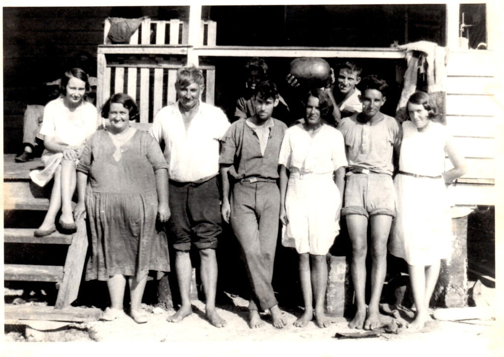
A Growing Community in the Depression Era
During the Depression era of the 1930s, the lure of cheap land helped establish a small but permanent population in Tin Can Bay. Local pioneer Viv Mason played a key role in shaping the young township, opening its first shop in 1932 at the site of what is now Jew Street. The shop quickly became a community hub.
Viv was instrumental in the town’s early development as he helped extend the telegraph line to Tin Can Bay, established a post office and ran a local transport service. In true community spirit, he even brought a horse from his family’s farm at Sandy Creek to plough a paddock below the shop and create the town’s first tennis court.
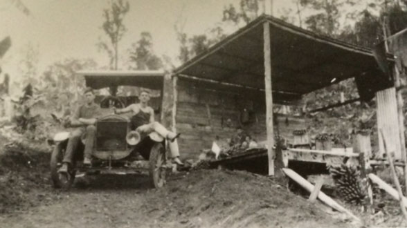
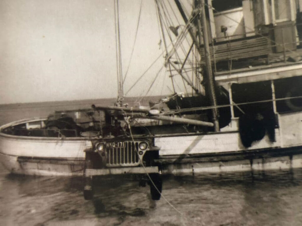
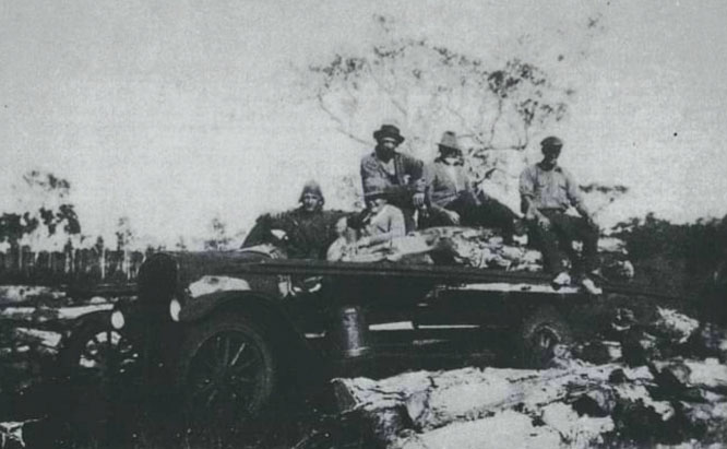
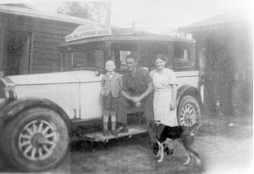
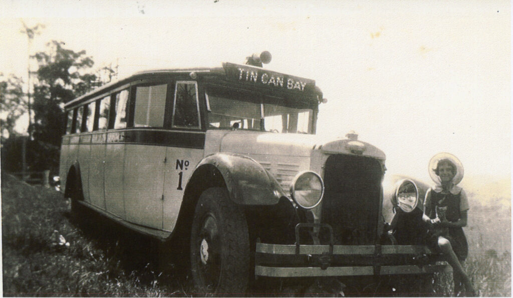
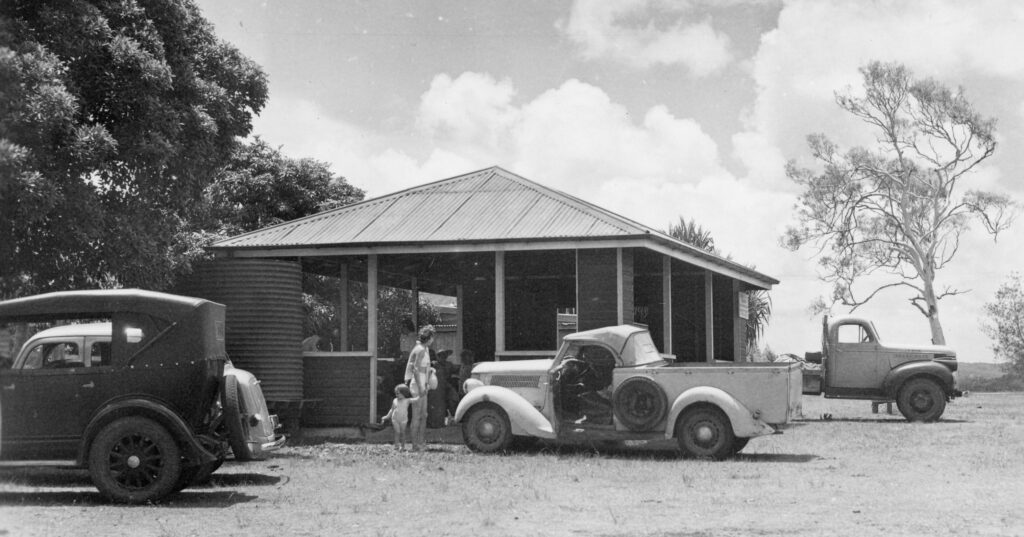
Early Transport to and from Tin Can Bay
In the early days, travelling to and from Tin Can Bay was far more challenging than it is today. Few residents owned vehicles and road conditions were often rough or unreliable.
The first regular transport service was established by Viv Mason, a pioneering local who played a major role in shaping the town’s early infrastructure. Later, in the 1940s and early 1950s, Bert Rogers operated the Tin Can Bay Transport Company, which became a vital link between the bay and surrounding regions.
Bert hauled fuel into Tin Can Bay, primarily for the growing trawler fleet and on his return trips to Gympie, he carried freshly caught fish, packed in ice, to the Gympie Railway Station, from where they were shipped to the Brisbane markets.
Another key figure in early local transport was Duncan Polley, who operated from a depot located where the Tin Can Bay Road shopping complex now stands, near Jew Street.
These early transport services were critical in supporting Tin Can Bay’s development and connecting the coastal community with the rest of Queensland.
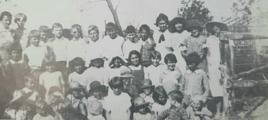
The Birth of Education in Tin Can Bay
As the population of Tin Can Bay grew in the early 1930s, so did the need for a school. Local shopkeeper and community leader Viv Mason recognised this and helped form a Building Committee to make it a reality. The committee included Joseph Rogers (Chairman), Martin Scullett (Treasurer), Viv Mason (Secretary), Thomas Impey, and William Payne.
Thanks to their dedication and hard work, especially during the difficult Depression era, Wallu School officially opened on 1 February 1934 with 28 children enrolled, under the guidance of headteacher Herbert Court. The schoolhouse had been relocated from Wolvi School to a site where Tuncunba Gardens stands today.
Within a few years, enrolments had grown to 36 students and the original building was no longer sufficient. In 1937, a larger school building was transported from Bell’s Creek and in the same year, the school’s name was changed from Wallu to Tin Can Bay.
The original schoolhouse was sold at auction to the Powell family, who moved it to Bream Street for use as a holiday home. It remained there until 1964, when it was demolished by F. Langford to make way for a new residence.
A Glimpse into Tin Can Bay’s Dairy Days
Long before pasteurised milk graced the shelves of modern stores, the people of Tin Can Bay relied on the local dairy and getting their milk straight from the farm. At the heart of this was the Burkhardt family, who ran a dairy right in the bay. In 1947, their operation was passed down to their daughter, Vera, and her husband, Henry “Chook” Mallett.
According to local lore, Henry earned his nickname during his school days. With two boys named Henry in the same class, teachers needed a way to tell them apart so one became “Chick,” and the other “Chook,” a name that stuck with him for life. Together, Vera and Chooky continued the dairy business, becoming well-loved pillars of the community.
After the farm eventually closed, Chooky remained deeply connected to Tin Can Bay. He worked in net fishing, the forestry industry and at the Fish Board, among other roles. He and Vera earned great respect from their neighbours for their contributions, work ethic and kindness.
Today, H.A. (Chooky) Mallett Park, located behind the Dolphin Shopping Centre on Dolphin Avenue, stands as a tribute to his legacy and his lasting impact on Tin Can Bay.
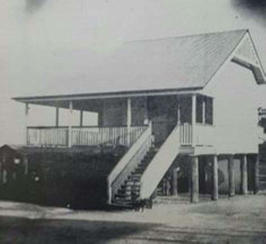
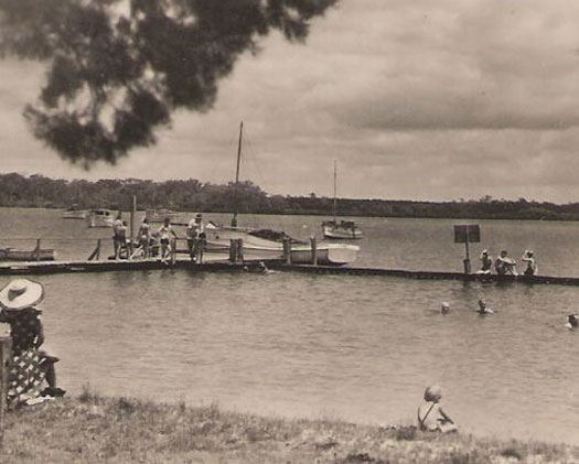
The Snapper Creek Jetty & Bathing Enclosure
In January 1932, the Lands Department gazetted a Reserve for Bathing Purposes at Snapper Creek. By August that year, the Widgee Shire Council had secured approval from the Maryborough Harbour Master to construct a bathing enclosure and jetty at the site.
The structure was built using durable Fraser Island Turpentine timber, chosen for its strength and resistance to marine borers. A U-shaped design formed the bathing enclosure, which quickly became a local favourite. The facility was officially opened on 7 April 1935 by the Tin Can Bay Progress Association.
As popularity grew, the jetty underwent a reconstruction in 1942 to support the increasing number of moorings and visitors. For over six decades, it served as a beloved spot for swimming, fishing and sailing lessons.
By the late 1990s, however, the ageing structure had deteriorated beyond repair. The public jetty was demolished and replaced with private moorings, marking the end of an era for this cherished community landmark.
The Cod Street Shelter Shed
In 1939, a site on Cod Street was selected for a shelter shed due to its close proximity to the Tin Can Bay jetty and bathing enclosure. Constructed through community labour in a “picnic-like atmosphere,” the 30-foot by 18-foot structure was completed by May 1940 using solid hardwood timber supplied by the Widgee Shire Council.
A concrete floor was added in 1944, with etchings in the slab marking its completion on 8 December. Over the years, visitors carved names and messages into the timber, leaving behind personal memory marks that became part of the shed’s legacy.
Sadly, after decades of service, the structure succumbed to white ant infestation and was removed in 2009. The area the shelter shed once stood is opposite Viv Mason Park just down from the big fig on Cod St.
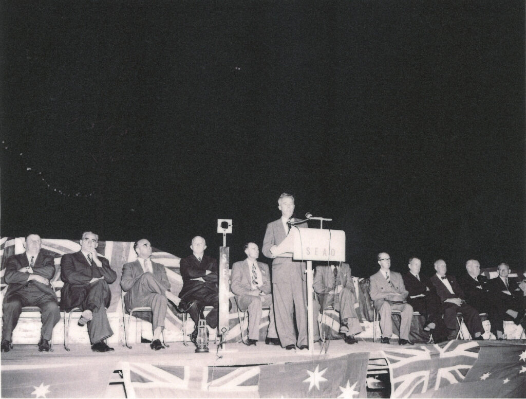
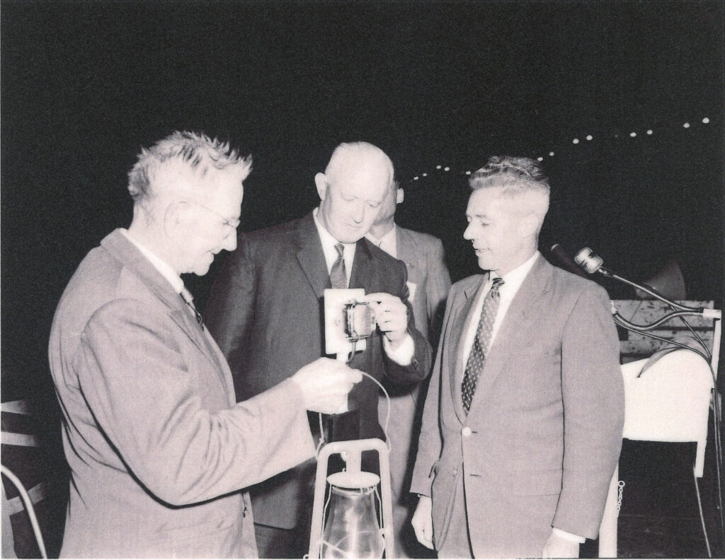
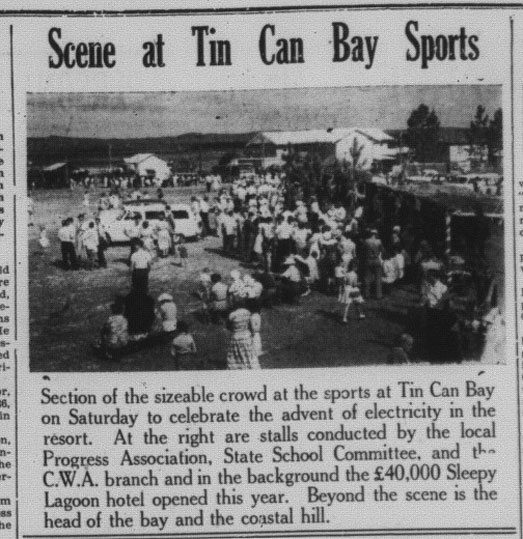
Electricity Comes to Tin Can Bay
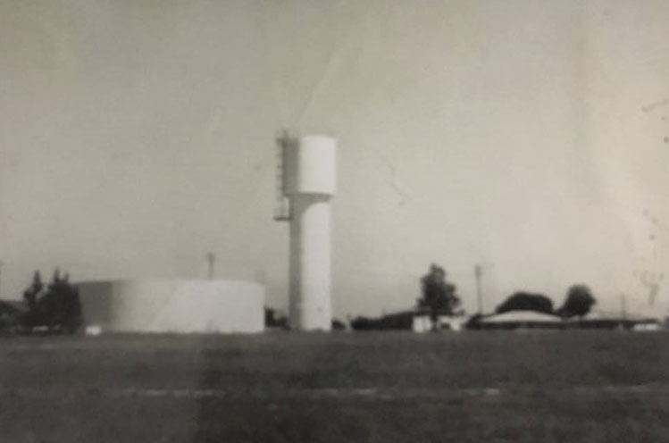
In September 1959, electricity was officially switched on in Tin Can Bay, marking a major milestone for the township. Instead of traditional copper, the extension from Gympie used steel-core aluminium cables—a lighter, more tensile alternative that required fewer posts, helping to keep the project cost-effective.
At the official ceremony, State Treasurer Mr. T.A. Hiley symbolically extinguished a kerosene lamp, representing the end of an era, before the power was ceremoniously switched on.
Town Water Supply
The Tin Can Bay township water supply was established in 1967 and was officially opened on 9 December by the Minister for Education, the Hon. J.C.A. Pizzey. The original water tower, a symbol of this important development, still stands today on Cr Tom Steele Park opposite the Sleepy Lagoon Hotel.
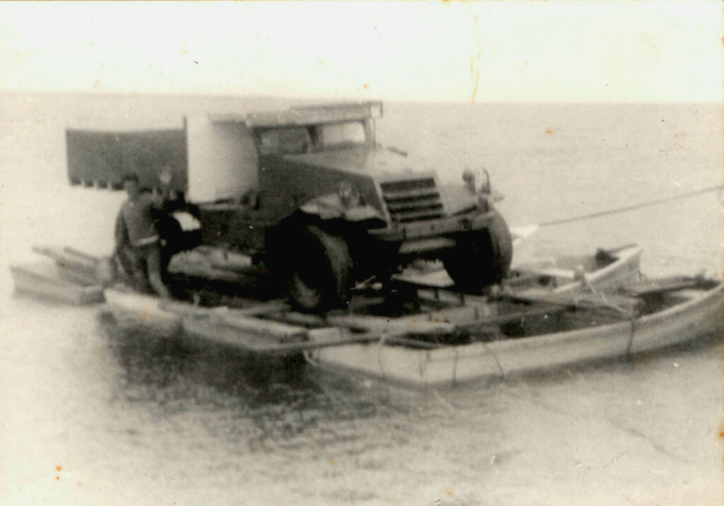
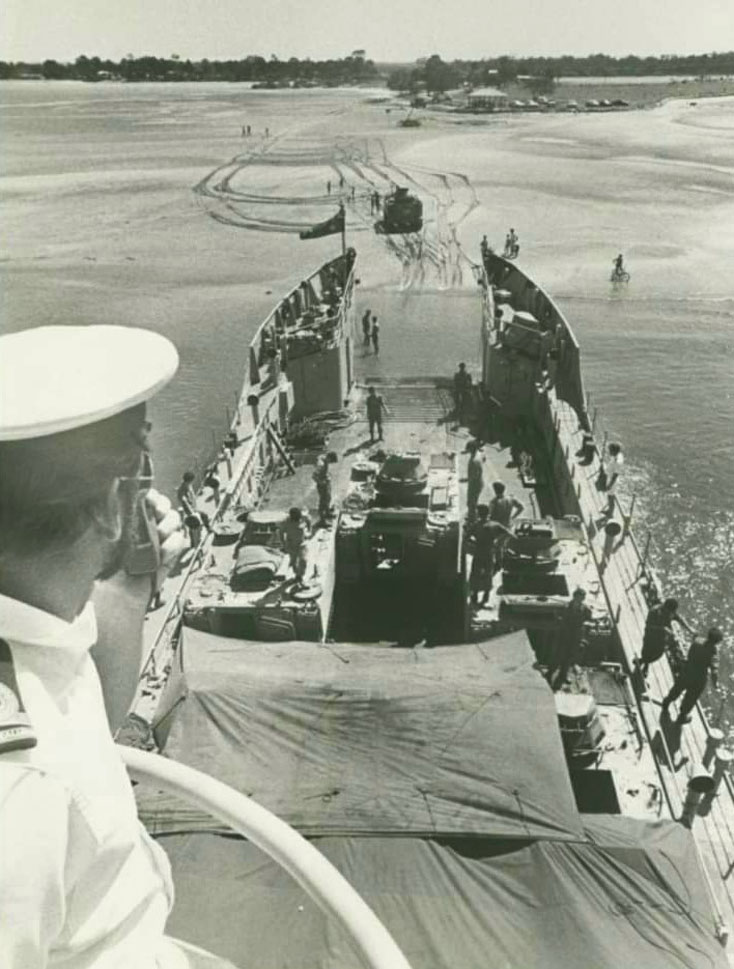
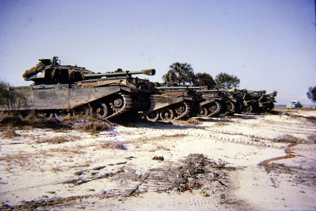
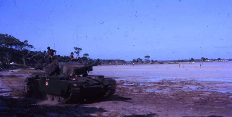
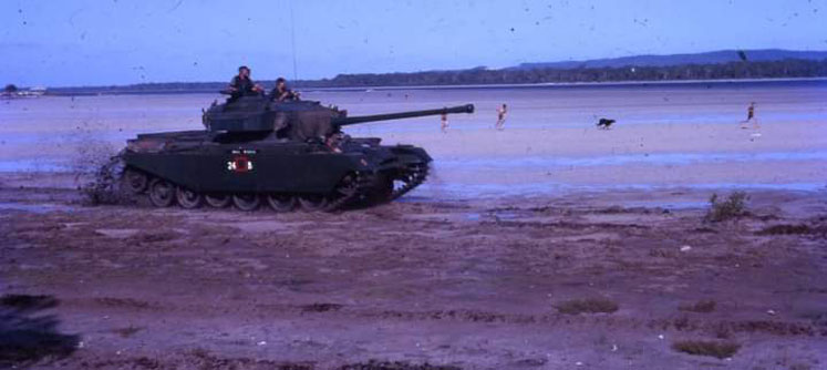
Wide Bay Training Area & Camp Kerr
The Wide Bay Training Area (WBTA), encompassing approximately 22,300 hectares, is situated just northwest of Tin Can Bay. Initially utilized by the military in the late 1940s, the land was officially acquired in 1953. The main base within the WBTA, known as Camp Kerr, was named in honour of Major General Donald Kerr, CBE, ED, a distinguished officer of the 2nd Australian Imperial Force and the first Queenslander to attain the rank of Major General in the Citizen Military Forces.
Over the decades, the Wide Bay Training Area (WBTA) has played a crucial role as a training ground for both Regular and Reserve units of the Australian Army. It has hosted a wide range of exercises, including live-fire artillery drills, armoured vehicle manoeuvres, and urban warfare simulations. Due to its proximity, military training has also extended into and around the Tin Can Bay township at various times — a practice that continues today during select periods throughout the year.
The training area is also recognized for its environmental significance. It forms a continuum of natural environments with Fraser Island and the Cooloola National Park, supporting diverse ecosystems ranging from estuarine wetlands to open forests.
In addition to its military and environmental roles, the WBTA has historical importance. During World War II, the area was associated with the 47th Battalion, known as the “Wide Bay Regiment,” which conducted training activities in the region.
Today, the WBTA continues to be an essential component of Australia’s defence infrastructure, facilitating ongoing training exercises that contribute to the readiness and capability of the nation’s armed forces. Training exercises are also sometimes held around the Cooloola Coast townships throughout the year.
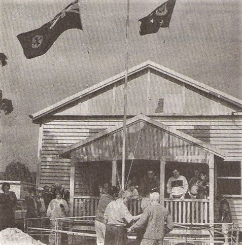
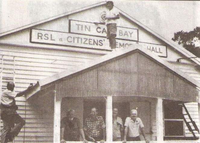
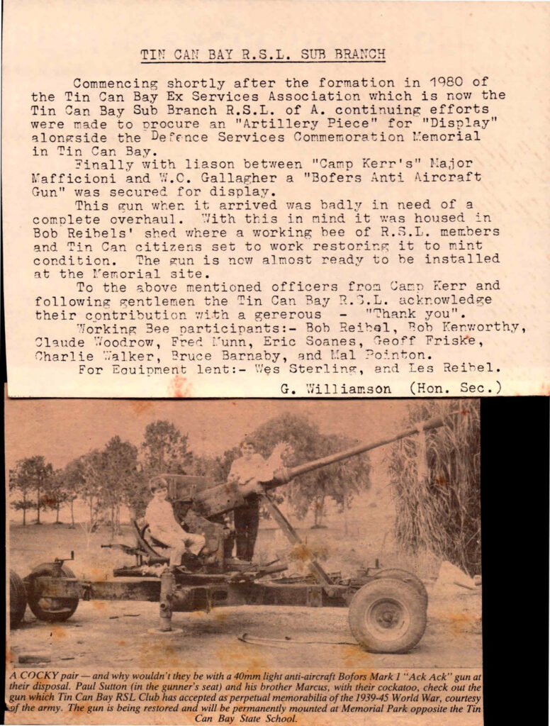
Tin Can Bay RSL & Citizens Memorial Hall
Originally built in 1923 by Queensland Railways, the hall at Sexton served as a School of Arts, a social venue, a community meeting space, and a library. However, in the early 1950s, changes to the railway structure meant Sexton was no longer a key changeover point, leading to a population decline and the hall falling out of use.
In the late 1950s, the Tin Can Bay Progress Association was seeking a community hall. Bob Reibel proposed acquiring the disused Sexton Hall. With approval, Bob and Les Reibel led a team that carefully dismantled the building, numbering each board then transported and reassembled it in Tin Can Bay. The hall still stands today, serving as a lasting symbol of community spirit and resourcefulness.
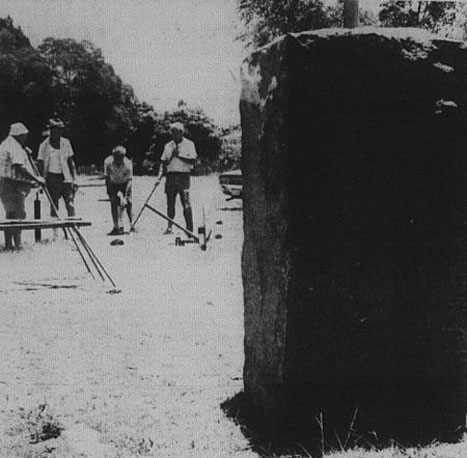
The Story of ANZAC Memorial Park
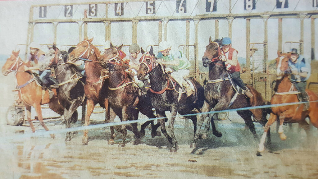
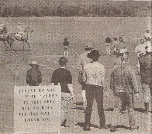
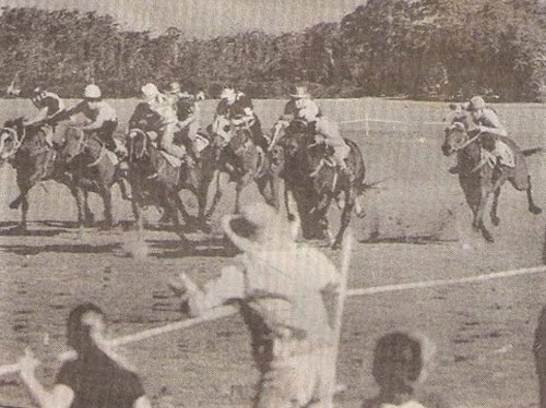
Across the road from the original Tin Can Bay school grounds stands ANZAC Memorial Park, a place built not merely with materials, but with community spirit. Located on the corner of Gympie Road and Whiting Street, the park was a truly local initiative, with members of the Tin Can Bay Ex-Services Association playing an active, hands-on role in its creation.
In the 1980s, the community sought a meaningful centerpiece for the park and sourced a 40mm light anti-aircraft Bofors Mark I “Ack Ack” gun. Before it could take pride of place, the gun underwent a detailed restoration. It was stored in Bob Reibel’s shed, where a dedicated group of volunteers — Bob Kenworthy, Bob Reibel, Claude Woodrow, Fred Munn, Eric Soanes, Geoff Friske, Charlie Walker, Bruce Barnaby, and Mal Pointon — worked tirelessly to bring it back to life.
Their efforts were supported by equipment generously lent by Les Reibel and Wes Sterling, making the gun’s restoration a truly collective endeavour. Thanks to this commitment, the restored Bofors gun now stands in ANZAC Memorial Park as a tangible reminder of service, sacrifice, and the unity of the Tin Can Bay community
Picnic Races
In the 1990s, Tin Can Bay hosted unique horse racing events known as the Picnic Races. These races took place on the foreshore sandflats near Wes Mitchell Park. A 400-meter track was prepared as the tide receded, including the installation of starting gates. Races had to conclude before the tide returned, adding a distinctive challenge to the event. This creative use of the natural environment showcased the community’s ingenuity and added a memorable chapter to Tin Can Bay’s local traditions.